Map and directions
Salford Royal is about four miles west of Manchester city centre and is easily accessible by public transport. We do have two car parks but they are very busy; you may have a long wait at peak times. Wherever possible please use public transport, come by bike or walk, Exercise reduces the risk of chronic illnesses, such as heart disease, type 2 diabetes, asthma, stroke and some cancers. It makes you feel better too.
Our address
Salford Royal NHS Foundation Trust
Stott Lane
Salford
M6 8HD
The main Salford Royal site is located next to the M602 (Junction 2), making it easily accessible from all parts of Greater Manchester and the North West.
Getting to the hospital
On Foot or By Bike
See the WalkIt website for details of pedestrian routes to the hospital.
Cycle routes to the hospital can be found on the TfGM website:
 http://cycling.tfgm.com. We have lots of secure bicycle stands.
By Public Transport
Transport for Greater Manchester has information about all forms of public transport on :
Their website:
www.tfgm.com
Telephone:
 0871 200 22 33
Bus, train and tram routes in Salford are shown on Map 3 which is available at all their Travel Shops.
By Train 
The nearest rail station is Eccles, a 20 minute walk away.
There are direct services from Manchester and Liverpool.
On leaving the station turn right crossing the motorway bridge and right again along Wellington Road for 300 yards. Use the subway to cross Eccles Old Road and turn left past Sainsbury’s. The hospital is 500 yards ahead.
By Tram 
The nearest tram stop is Ladywell, on the Eccles Line. It is a 10-15 minute walk away.
By Bus 
Buses stop right outside our main entrance. There are frequent direct services from Manchester Shudehill, Salford Shopping Centre, Eccles, Cadishead, Farnworth, Walkden, Worsley, Trafford Centre, Rusholme, Didsbury, Failsworth, Newton Heath, Cheetham Hill, Swinton and Prestwich.
By Taxi 
The taxi drop-off point is in the main hospital grounds off Eccles Old Road.
By Car  or Motorbike
Please use postcode M6 8HD if you are using sat-nav to find your way to the hospital.
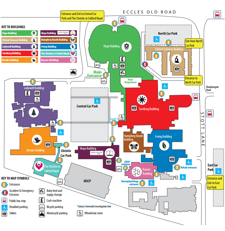
Finding your way around the hospital
Buildings on Salford Royal’s site are distinguished by their name, colour and a symbol to help patients and visitors find their way around. Signage and maps on the site reflect this. Patient appointment letters will tell you the name of the department/ward you will be attending, along with the building and the level/floor this is located on.
The Main Outpatients Department is located near the Main Entrance in Hope Building. The lifts and stairs leading to Main Outpatients are opposite the café and M&S Simply Food.